Introducing the Model Fault Flag
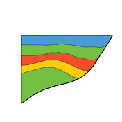
This video demonstrates how the new Model Fault Only stratigraphic flag separates modeling faults from interpretation faults, allowing structural models to be tested without disrupting horizon intersections, coloring, or area-depth analysis. *00:00 – Introducing Model Fault Only faults* Alan introduces the new fault stratigraphic flag in StructureSolver 8.1 and explains how it distinguishes faults used for structural modeling from faults used in the primary interpretation. *00:28 – Reviewing the interpreted Niger Delta example* The example section is reviewed, including automatic coloring, projected horizons, and an area-depth graph based on the interpreted horizons and faults. *01:29 – Why superimposed model faults cause problems* Alan turns on a separate forward-modeling fault and shows how overlapping interpreted and model faults create warnings, double intersections, spurious projected horizons, and invalid area-depth results. *02:53 – Applying the Model Fault Only flag* The model fault is set to Model Fault Only, excluding it from horizon-fault intersections while still allowing the model geometry and displacement results to be compared with the interpretation. *04:01 – When to use model-only faults* Alan explains why modelling faults are often simpler than interpreted faults, and how the new flag supports integrated interpretation and modeling workflows. The title image is a view of the rugged and remote Warawara Range on the western shore of the Hokianga Harbour in Northland, NZ. The range consists of a slab of upper oceanic crust (part of the Cretaceous Tangihua complex) which was thrust southwestward over Northland during the emplacement of the Northland Allochthon in the Late Oligocene, prior to the establishment of subduction on New Zealand's northeastern margin. The final video pans southward from the Warawara Range to the Koutu Boulders on the eastern foreshore of the harbor. These concretions are formed in the Early Cretaceous Punakitere Sandstones, which were also emplaced as part of the Northland Allochthon. These sandstones most probably underly the Warawara Range and in turn overly younger Tertiary sedimentary thrust sheets. Finally in the distance the video shows the large Quaternary sand dunes which cover the northern headland of the Hokianga Harbour. (Geology of the Kaitaia Area, 1:250,000 Geological Map and accompanying text, 1996, M.J. Isaac (compiler), GNS Science, New Zealand). #StructureSolver #StructuralGeology #SeismicInterpretation #KinematicStructuralModeling
Download
1 formatsVideo Formats
Right-click 'Download' and select 'Save Link As' if the file opens in a new tab.